The HUNGARIAN VILLAGE
FINDER, ATLAS, and GAZETTEER for the KINGDOM of HUNGARY (HVF)-
available for DOWNLOAD
or on CD-ROM, lists and provides
information for
ALL of the following towns, villages,
cities, places, settlements, and place
names associated with Komarom
County - megye - varmegye located in the
old Austria-Hungary or
Austro-Hungarian Empire, now in Hungary
and Slovakia.
Notes--Smaller
places such as pusztas and many other variations in a town's spelling
or name are not listed here, however, they, along with current place
names can all be found in the HVF...
software program.
While the place names in the following table have had all
accents and special letters removed for simplication in web site
searching, the HVF... software
program offers several methods of researching
place names including with or without the proper accents. (Hint) Learning and using the proper spelling of
place names, including the use of special letters or letters with
accents, can be key to your success in searching the internet for
websites related to the place of interest.
-
ABOUT
-
the
HUNGARIAN VILLAGE FINDER,
ATLAS, and GAZETTEER
for the
KINGDOM
of HUNGARY

INDEX
for the

Atlas, and Gazetteer for the
Kingdom of Hungary
(see what the HVF offers...)
MAPS

Find the location of your village or town in seconds with the
Hungarian Village Finder...
View EXAMPLE
pages

from the
Hungarian Village Finder...
software program
How the HVF can help with
your genealogy research

QUESTIONS

regarding the HVF...
ORDER

GUESTBOOK
Read what others say about the
HUNGARIAN VILLAGE FINDER,
ATLAS, and GAZETTEER
for the
KINGDOM of HUNGARY
or add your own comments

HOME
|
Csallokoz Jaras
Gesztes Jaras
Komarom Megye
Komarom Varmegye
Tata Jaras
Udvard Jaras
Acs
Agostyan
Alsobanhida
Alsogalla
Alsogeller
Alt Komorn
Alt-Komorn
Apacaszakallas
Aranyos
Arcibiskupsky Lel
Aszar
Augustin
Bagota
Baj
Bajc
Bajcs
Bana
Banhida
Baromlak
Bodza
Bogya
Bohata
Bokod
Branovo
Brestovec
Calovec
Cechy
Chotin
Cicov
Comorn
Csallokozaranyos
Csaszar
Csehi
Csep
Csicso
Csuz
Dad
Dolny Geller
Dubnik
Dulovce
Dunaalmas
Dunaradvany
Dunaszentmiklos
Dunaujfalu
Dvory nad Zitavou
Ekecs
Ekel
Erseklel
Ete
Felsobanhida
Felsogalla
Felsogeller
Fur
Fuss
Geller
Geschtitz
Gesstitz
Gesztes
Guta
Gyermely
Hereg
Heteny
Holiare
Horny Geller
Hurbanovo
Imel
Imely
|
Iza
Izop
Izsa
Izsap
Jasova
Jaszfalu
Kamenicna
Kamocsa
Katschka
Kecsked
Keszegfalva
Kethely
Kirne
Kisbaromlak
Kisber
Kisigmand
Kiskeszi
Klizska Nema
Kocs
Kolarovo
Kolozsnema
Kolta
Komarno
Komarom
Komaromcsehi
Komaromfuss
Komaromszemere
Komaromszentpeter
Komaromujvaros
Komlod
Kommorn
Komoca
Komorn
Kornye
Kratke Kesy
Kurt
Kurtakeszi
Lakszakallas
Madar
Marcelhaza
Marcelova
Martos
Martovce
Megyercs
Mocsa
Modrany
Nagyigmand
Nagykeszi
Nagymegyer
Nagytany
Naszaly
Naszvad
Nemesocsa
Nesvady
Neszmely
Niglo
Niklo
Nova Straz
Obergalla
Ocsanemes
Ogyalla
Okoc
Okolicna na Ostrove
Opatovsky Sokolec
Oroszlany
Orsujfalu
Oszony
Perbete
Pribeta
Pusztagyarmat
Radvan nad Dunajom
Ruban
Schemlenz
Schemling
|
Semerovo
Sokolce
Somor
Strekov
Sumur
Svaty Peter
Szak
Szakszend
Szemere
Szend
Szent Peter
Szent-Peter
Szentpeter
Szilas
Szimo
Szollos
Szomod
Szomor
Szony
Tany
Tardos
Tarian
Tarjan
Tarkany
Tata
Tatabanya
Taunar
Taunau
Tolna
Tolnau
Ton
Totis Seestadt
Totis-Seestadt
Tovaros
Travnik
Turi Szakallas
Turiszakallas
Udvard
Ujgyalla
Ujszony
Untergalla
Vargesztes
Velke Kosihy
Velky Meder
Verteskethely
Vertessomlo
Vertesszolos
Vertestolna
Weinhied
Woj
Zemianska Olca
Zemne
Zlatna na Ostrove
Zsemlye
|
Based on the 1877
Hungarian Gazetteer "Magyarorszag Helysegnevtara" by Janos Dvorzsak, the
HUNGARIAN VILLAGE FINDER,
ATLAS, and GAZETTER for the KINGDOM of HUNGARY CD-ROM—
Is a comprehensive dictionary, encyclopedia, atlas, gazetteer, and
directory with indexes of placenames for villages, settlements, towns,
communities, and cities in the former Kingdom of Hungary (pre 1918),
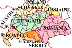
including those now located in Austria, Croatia, Hungary, Poland,
Romania, Slovakia, Slovenia, Ukraine, and Serbia / Yugoslavia.
Functions as a village finder, place locator, and town seeker when
conducting a place name search.
Uses official, native, conventional, variant, and current names to make
finding a place of interest a more likely probability.
Allows for partial name or word searching when available records are
difficult to read and only a few letters are legible.
Has reference maps for
individual countries, megyes / varmegyes (counties), AND for every járás
(district) located within each county. These so-called district
maps show the location of the
villages that were once part of the Austro-Hungarian Empire!
Also includes indexed county / megye directories listing local churches
and nearby parishes (to help locate ancestor birth, marriage, and death
records), information on population and ethnicity of major inhabitants,
current country locations with names, as well as other relative
information, research aids, hints, and “Links” to online/Internet
websites.
No other resource
gives you so much in one place.
|
|