|
The HUNGARIAN VILLAGE
FINDER, ATLAS, and GAZETTEER for the KINGDOM of HUNGARY (HVF)- available
for DOWNLOAD
or on CD-ROM, lists and provides maps and
information for
cities, towns, places, villages, settlements, and place names located
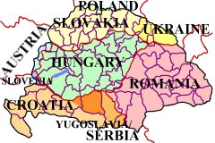
in ALL of the following 71 counties, megyes, or varmegyes which, prior
to the 1920 Treaty of Trianon,
were part of the old Austria-Hungary, Austro-Hungarian
Empire, or Kingdom of Hungary. Currently, these counties, are
divided among Austria, Croatia, Hungary, Poland, Romania, Slovakia,
Slovenia, Serbia / Yugoslavia, and Ukraine.
-
ABOUT
-
the
HUNGARIAN VILLAGE FINDER,
ATLAS, and GAZETTEER
for the
KINGDOM
of HUNGARY

INDEX
for the

Atlas, and Gazetteer for the
Kingdom of Hungary
(see what the HVF offers...)
View EXAMPLE
pages

from the
Hungarian Village Finder...
software program
Looking for
MAPS

See what the HVF has to offer
How the HVF can help with
your genealogy research

QUESTIONS

regarding the HVF...
ORDER

GUESTBOOK
Read what others say about the
HUNGARIAN VILLAGE FINDER,
ATLAS, and GAZETTEER
for the
KINGDOM of HUNGARY
or add your own comments

HOME |
Magyarország
(county, varmegye, megye,
comitatus)
1. Abauj-Torna
2. Alsó-Fehér
3. Arad
4. Arva
5. Bács-Bodrog
6. Baranya
7. Bars
8. Békés
9. Bereg
10. Besztercze-Naszód
11. Bihar
12. Borsod
13. Brassó
14. Csanád
15. Csik
16. Csongrád
17. Esztergom
18. Fejér
19. Fogaras
20. Gömör
21. Gyõr
22. Hajdu
23. Háromszék
24. Heves
25. Hont
26. Hunyad
27. Jász-Nagy-Kun-Szolnok
28. Kis-Küküllõ
29. Kolozs
30. Komárom
31. Krassó-Szörény
32. Liptó
33. Máramaros
34. Maros-Torda
35. Moson
36. Nagy-Küküllõ
37. Nógrád
38. Nyitra
39. Pest-Pilis-Solt-Kis-Kun
40. Pozsony
41. Sáros
42. Somogy
43. Sopron
44. Szabolcs
45. Szatmár
46. Szeben
47. Szepes
48. Szilágy
49. Szolnok-Doboka
50. Temes
51. Tolna
52. Torda-Aranyos
53. Torontál
54. Trencsén
55. Turócz
56. Udvarhely
57. Ugocsa
58. Ung
59. Vas
60. Veszprém
61. Zala
62. Zemplém
63. Zólyom
|
Horvát-Szlavonország
(county, varmegye, megye,
comitatus)
64. Belovár-Körös
65. Lika-Korbava
66. Modrus Fiume
67. Pozsega
68. Szerem
69. Varasd
70. Verőce
71. Zágráb
|
Based on the 1877
Hungarian Gazetteer "Magyarorszag Helysegnevtara" by Janos Dvorzsak, the
HUNGARIAN VILLAGE FINDER,
ATLAS, and GAZETTER for the KINGDOM of HUNGARY CD-ROM—
Is a comprehensive dictionary, encyclopedia, atlas, gazetteer, and
directory with indexes of placenames for villages, settlements, towns,
communities, and cities in the former Kingdom of Hungary (pre 1918),
including those now located in Austria, Croatia, Hungary, Poland,
Romania, Slovakia, Slovenia, Ukraine, and Serbia / Yugoslavia.
Functions as a village finder, place locator, and town seeker when
conducting a place name search.
Uses official, native, conventional, variant, and current names to make
finding a place of interest a more likely probability.
Allows for partial name or word searching when available records are
difficult to read and only a few letters are legible.
Has reference maps for
individual countries, megyes / varmegyes (counties), AND for every járás
(district) located within each county. These so-called district
maps show the location of the
villages that were once part of the Austro-Hungarian Empire!
Also includes indexed county / megye directories listing local churches
and nearby parishes (to help locate ancestor birth, marriage, and death
records), information on population and ethnicity of major inhabitants,
current country locations with names, as well as other relative
information, research aids, hints, and “Links” to online/Internet
websites.
No other resource
gives you so much in one place.
|
|